 |
|

|


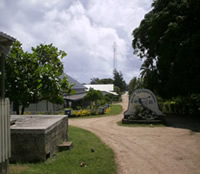
OUR ISLAND IS LIFUKA, one of the 70 or so islands that makes up the Ha'apai district of the Kingdom of Tonga. Although it may be confusing, there is no island named Ha'apai, and when one speaks of the Ha'apai area one is usually referring to the islands of Lifuka and Foa which are connected by a causeway.
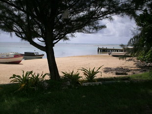 This
is the waterfront of Pangai, the main city on Lifuka and the place most
often referred to when one speaks about Ha'apai. The little jetty in this
photo is a favorite place for Simba and I to go swimming. There are several
local fishing boats here, and often you will see one docked at this jetty
to unload the catch for the marketplace close by. This view is at 'half
tide' so some boats are up on the shore and some are still afloat. You
can see a little bit of the small breakwater behind the jetty. Ha'apai
harbor is not very protected and in the case of a big storm it is not
a good place for sailboats and yatchs to hide from the storm.
This
is the waterfront of Pangai, the main city on Lifuka and the place most
often referred to when one speaks about Ha'apai. The little jetty in this
photo is a favorite place for Simba and I to go swimming. There are several
local fishing boats here, and often you will see one docked at this jetty
to unload the catch for the marketplace close by. This view is at 'half
tide' so some boats are up on the shore and some are still afloat. You
can see a little bit of the small breakwater behind the jetty. Ha'apai
harbor is not very protected and in the case of a big storm it is not
a good place for sailboats and yatchs to hide from the storm.
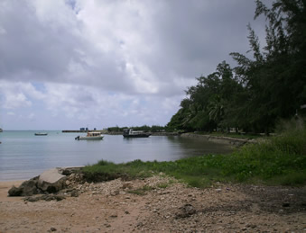 This
is the view up along the waterfront towards the main wharf from the fishing
jetty. There are several boats moored along the way including the british
landing boat that was a gift to the governor. I have never seen this boat
go out from the harbor, and they tell me it is very expensive to repair.
There are a few containers on the main wharf back there. When the yachties
come in to Ha'apai this is where you will see them lined up. It's also
a place where locals wait for their ride to a neighbor island to come
in. On Friday afternoon there are lots of locals going back to their homes
on Ha'ano or Uiha, the two nearest islands without road access (or horseback
access in the case of Uoleva). Sometimes you will find people going out
to Ha'afeva or Nomuka, a bit further out from here.
This
is the view up along the waterfront towards the main wharf from the fishing
jetty. There are several boats moored along the way including the british
landing boat that was a gift to the governor. I have never seen this boat
go out from the harbor, and they tell me it is very expensive to repair.
There are a few containers on the main wharf back there. When the yachties
come in to Ha'apai this is where you will see them lined up. It's also
a place where locals wait for their ride to a neighbor island to come
in. On Friday afternoon there are lots of locals going back to their homes
on Ha'ano or Uiha, the two nearest islands without road access (or horseback
access in the case of Uoleva). Sometimes you will find people going out
to Ha'afeva or Nomuka, a bit further out from here.
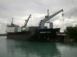 Ships with cranes can unload containers in Ha'apai. This ship comes from
New Zealand several times a year to bring containers of cargo and to take
back mostly empty ones. The containers are maneuvered onto the wharf area
by cranes but then must be unloaded by hand onto trucks. The containers
never leave the area adjacent to the dock where they arrive. Weekly ferry
boats move most of the cargo into and out of Ha'apai. Those two, the Olovaha
and Pulupaki leave Nuku'alofa on Monday and Tuesday, arrive in Ha;apai
early in the morning, then head up to Vava'u. Then they turn right around
and go back down. The Olovaha heads way out to the Niua's (Niuatoputapu
and Niuafo'ou) every month or so after docking in Vava'u.
Ships with cranes can unload containers in Ha'apai. This ship comes from
New Zealand several times a year to bring containers of cargo and to take
back mostly empty ones. The containers are maneuvered onto the wharf area
by cranes but then must be unloaded by hand onto trucks. The containers
never leave the area adjacent to the dock where they arrive. Weekly ferry
boats move most of the cargo into and out of Ha'apai. Those two, the Olovaha
and Pulupaki leave Nuku'alofa on Monday and Tuesday, arrive in Ha;apai
early in the morning, then head up to Vava'u. Then they turn right around
and go back down. The Olovaha heads way out to the Niua's (Niuatoputapu
and Niuafo'ou) every month or so after docking in Vava'u.
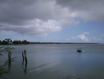 And
this is the view from the main harbor area back past the fishing jetty
towards the village of Hihifo, which is pretty much adjacent to Pangai.
You can see how open the whole harbor area is. The Royal residence is
visable at the left. In the back you can tell where the hospital and TCC
communications tower is. You can also see how Lifuka is a very flat island.
This little sailboat looks very lonely. Several of the 'Yachties' who
have come to visit Tonga have given up their travelling ways and find
happiness as a landlubber. I have'nt ever seen this little yacht go out
sailing, probably just another happy Ha'apai resident now.
And
this is the view from the main harbor area back past the fishing jetty
towards the village of Hihifo, which is pretty much adjacent to Pangai.
You can see how open the whole harbor area is. The Royal residence is
visable at the left. In the back you can tell where the hospital and TCC
communications tower is. You can also see how Lifuka is a very flat island.
This little sailboat looks very lonely. Several of the 'Yachties' who
have come to visit Tonga have given up their travelling ways and find
happiness as a landlubber. I have'nt ever seen this little yacht go out
sailing, probably just another happy Ha'apai resident now.
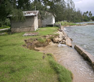
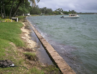 The
earthquake of May 2006 caused the whole island to sink about a foot, but
it may rise the same or more during the next one. This along with rising
sea levels due to global climate change presents a risk to Ha'apai that
is clearly evident in the photos here. This is not a particularly turbulent
sea that has breached the seawall along the waterfront. You can see in
the back that the ocean is just about up to the same level as the fishing
jetty too. The approach area to the jetty is awash with seawater during
particularly high tide periods. It is only a matter of time before the
approach will wash away and we will have to make repairs to reach the
jetty.
The
earthquake of May 2006 caused the whole island to sink about a foot, but
it may rise the same or more during the next one. This along with rising
sea levels due to global climate change presents a risk to Ha'apai that
is clearly evident in the photos here. This is not a particularly turbulent
sea that has breached the seawall along the waterfront. You can see in
the back that the ocean is just about up to the same level as the fishing
jetty too. The approach area to the jetty is awash with seawater during
particularly high tide periods. It is only a matter of time before the
approach will wash away and we will have to make repairs to reach the
jetty.
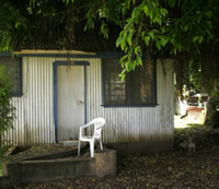
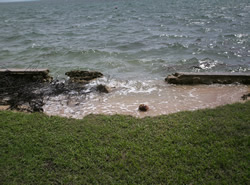 This
damage from the sea level rise is really disturbing and the cost of replacing
the seawall is a lot more than we have I am sure. The building in the
photo below was a public toilet, no longer in use. The septic tank is
now less than a meter from the ocean.
This
damage from the sea level rise is really disturbing and the cost of replacing
the seawall is a lot more than we have I am sure. The building in the
photo below was a public toilet, no longer in use. The septic tank is
now less than a meter from the ocean.